Who This Guide is For
This ag drone buyer’s guide is for farmers and agriculture service professionals who want to use unmanned aerial vehicles to monitor the health of crops and livestock.
It covers everything you need to know, including drone reviews of the leading UAVs used for precision agriculture; popular imaging software packages & services; a short list of UAV surveyors; and the latest FAA regulations governing use of drones in agriculture.
- If you are interested in flying your own fixed wing or multi-rotor agriculture drone, then this guide will tell you everything you need to know to select and buy the right UAV for your needs.
- If you plan to hire a third party to survey crops for you, then this guide will make you a smarter buyer.
In this guide you’ll learn about:
- the most popular ag drones selling today (fixed wing and multi rotor)
- how & why drones are used to scout fields & crops to check the health of plants
- the benefits & limitations of using drones vs. other aerial survey methods
- the different software and hardware components required
- how to get started – including a short list of ready-to-fly drone packages designed specifically for agriculture and a list of ag drone service companies you can hire to survey crops for you.
TIP: Use the Contents box in the upper right corner of this guide to view everything contained this guide, and to jump straight to what you’re after.
Professionals Only Please!
Agriculture drones are not your run-of-the-mill consumer-grade camera drone or racing drone. They are advanced data-gathering tools for serious professionals. Prices for complete, ready-to-fly ag drone systems range from $1,500 to well over $25,000.
There are two types of professionals who might want to own an agriculture drone:
- farmers who want to fly their own imaging missions; and,
- agriculture service providers and others who fly drones for farmers.
If you fit into either of these categories, then please note:
The FAA views all agricultural drone activity as commercial drone operation.
This means the drone operator must have a Remote Pilot Certificate to fly. This is true, even if no money changes hands.
To learn more about the FAA’s pilot requirements, check out our drone operator safety guide.
In other words, there’s no such thing as an amateur agriculture drone operator.
So, if you get pitched by a drone outfit claiming they don’t need a remote pilot certificate to survey your field, then run – far, far away.
The Best Agriculture Drones/UAVs (Ready To Fly)
Listed below are the most popular ready-to-fly agriculture drone/UAV/UAS systems in the world, both fixed-wing and multi-rotor.
All of these unmanned aerial survey drones are delivered ready-to-fly and are equipped with all the software, sensors and hardware you’ll need to check the health of crops, track livestock and survey farmland.
The market is changing quickly, however.
Some of the early entrants are gone now, and most suppliers update their prices, features, rigs and software packages on what seems like a monthly basis. Make sure you check the manufacturer’s website for the latest details.
The Best Fixed Wing Ag Drones
Fixed-wing UAVs are the best choice when you have to cover a lot of ground, fast. Fixed-wing ag drones can cover up to 10 times the acreage that a typical quadcopter can cover in a single flight.
That said, image quality can suffer due to the speed. For example, fixed wing UAVs are often unable to capture survey-grade 3D / topographic detail.
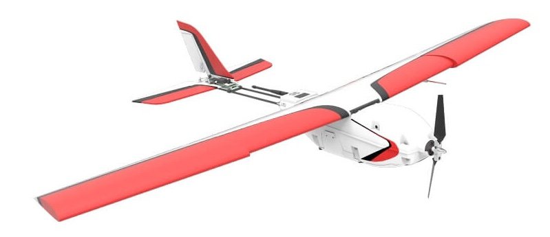
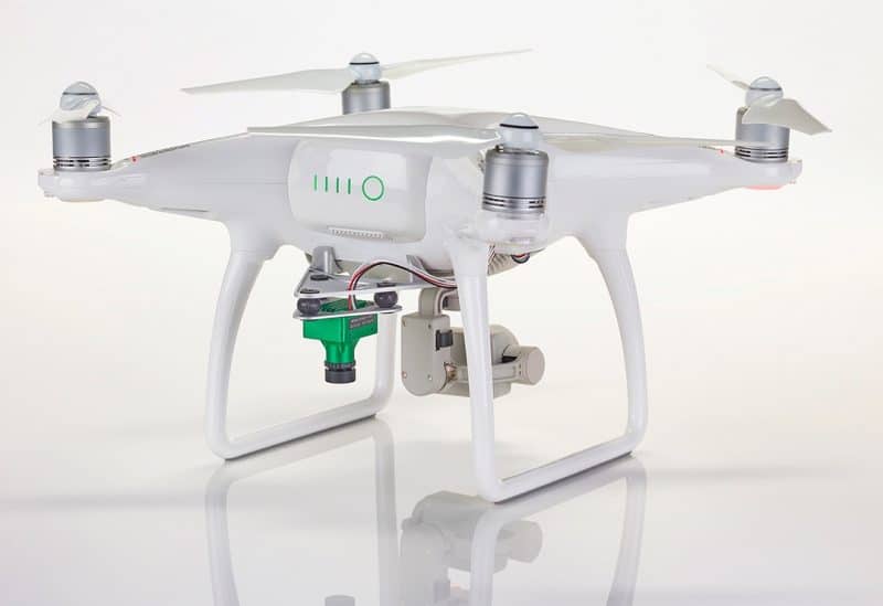
senseFly eBee SQ ($12,000+)
The eBee SQ is the latest update of the eBee Ag UAV, a proven and popular choice among ag service providers who need to cover a lot of ground, fast. To date, the eBee series has logged more than 300,000 missions.
A Complete Ag Solution
This drone is easy to fly and comes with senseFLY’s Sequoia 5-spectrum sensor (4 spectral bands + visible/RGB) and advanced, flight planning, flight management and image processing software designed specifically to work within a complete drone-to-tractor workflow.
Flight Planning Simplified
The eBee SQ includes their proprietary eMotion Ag flight planning and ground station software, making the process of creating a flight plan really simple.
To get started, just upload your field boundaries from your existing FMIS system, like Ag Leader’s SMS or Trimble’s FarmWorks; or, you can draw them on-screen.
To launch a new mission, the pilot only needs to establish the area to survey, set the image resolution and define the desired image overlap. Then, the software generates an optimal flight plan.
500 Acres in a Single Charge
Because this UAV is so fast, the eBee SQ can capture multi-spectral and visual data on hundreds of acres of crops in a single flight.
Once you’ve captured that data, you can process it using any popular software of your choice such as Pix4Dmapper Ag/Pro software, MicaSense ATLAS or AIRINOV to create vegetation index maps.
Some of the information you can capture in a single eBee flight include:
- Vegetation indices (NDVI, CCCI, NDRE, MCARI, CWSI, et al)
- Plant counts
- Soil H20 levels
- Soil temp
- Topography / 3D mapping (limited / not survey quality)
Take Action Now
Using your index maps, you can then generate prescription maps using Pix4Dmapper Ag (optional) & upload them into your FMIS system or a tractor; or, you can process the data further using another index map solution such as SMS, AgPixel, QGIS, ArcGIS, Global mapper and other popular GIS systems.
Specifications
- 1.1 kg / 2.4 lbs
- Sequoia multi-spectral sensor provides more accurate data than NIR options
- 55 minute flight time
- Up to 500 acres per flight (400 ft elevation, 12 cm/pixel resolution)
PrecisionHawk Lancaster 5 ($25,000+) – DISCONTINUED
Another very popular choice with ag surveyors, PrecisionHawk’s Lancaster fixed wing UAV carries the widest range of aerial sensors and is the most “intelligent” fixed-wing drone designed for agriculture.
The latest release, Lancaster 5, adds a ruggedized chassis that is more durable on hard landings; a new tail structure; a longer wingspan to improve stability; more intelligent on-board flight control.
Intelligent & Aware
In addition to the mandatory downward-facing multispectral sensor, the Lancaster carries on-board sensors that measure humidity, temperature, air pressure along with incident light, all in real time. It then uses artificial intelligence to react to changing weather conditions, payload, changing wind loads, visibility, etc.
Flight Planning
Flight planning couldn’t be simpler – just select your target altitude and desired ground resolution, and the Lancaster creates a flight plan automatically. Then, just toss the aircraft like a paper plane, to begin your survey.
When it’s finished, the Lancaster will land itself, automatically.
Flight Control
PrecisionHawks’ InFlight flight monitoring and tracking software gives you real-time data on flight path, position, altitude, aircraft performance and battery life.
Sensors
The Lancaster platform is built on open source software that makes it easy for developers to design & integrate sensors for any need. 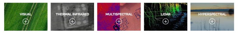
A wide range of sensors are available to capture visual, thermal/IR, multispectral, LIDAR and hyperspectral data.
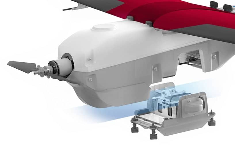
Changing a sensor is a snap, too – the process is 100% Plug and Play, with no configuration required.
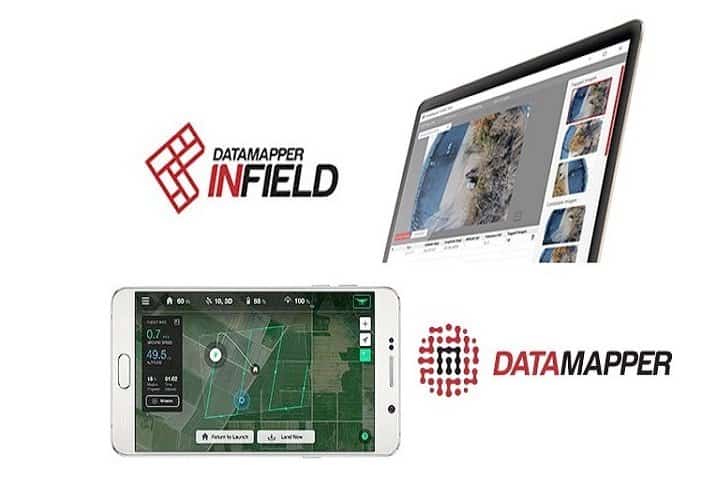
Mapping and Analysis
The Lancaster 5 comes with PrecisionHawk’s outstanding DataMapper data management and analysis solution. Available as desktop software or through the cloud, DataMapper produces accurate 2D and 3D maps into geo-referenced mosaics.
From there, you can process field data using algorithms and indexers available on the DataMapper AlgoMarket.
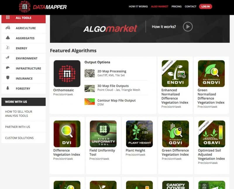
On AlgoMarket, you can select and purchase data processing for any purpose – a wide range of indices are available including:
- Plant height
- Plant count
- Enhanced NDVI
- Field Uniformity
- Volume measurement
- Optimized Soil Adjusted Vegetation Index (OSAVI)
- Water pooling
- And many more
PrecisionHawk Lancaster 5 Specifications
- 5.3 lbs dry weight
- 2.2 lb payload
- 45 minute flight time
- 2km / 1.2 mile range
- 300 acres per flight (300 ft altitude)
- Plug-and-Play sensor bay
- 5-channel multispectral camera available
- One-button press to launch (cool feature)
- Data resolution down to 1 cm/pixel
Other Fixed Wing Ag Drones
- AgDrone by HoneyComb ($10,000+): a complete hardware/software/data storage package with a variety of sensors available including NDVI, visual stereoscopic and NIR (thermal imaging). Flight times up to 55 minutes. Comes with flight planning/control software and all the hardware you need.
- Sentera Phoenix 2 ($18,000): a complete hardware, software and data storage solution designed for crop surveying. Captures RGB visual, NIR, NDVI and Live NDVI (streaming) during same flight. Covers 100 acres per flight.
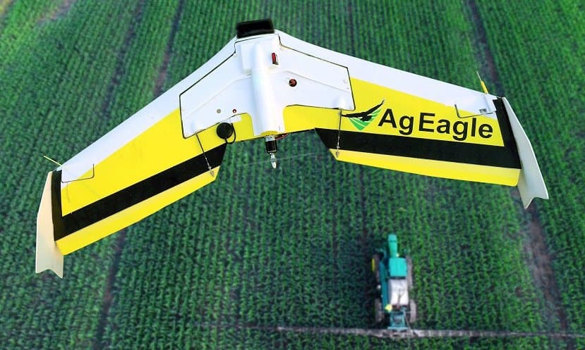
- AgEagle RX60: a super-rugged ‘flying wing’ made of fiberglass and carbon fiber, this UAV can fly for up to 60 minutes on a charge. Captures NDVI, NIR and visual images using GoPro and other sensors. Package includes aircraft, launcher, camera, software and training.
- Trimble UX5 ($25,000+): the French aerospace company, Trimble, sells its highly advanced UX5 drone in the US through local resellers. Hardware, software and processing are included. Using an optional MicaSense RedEdge or 24MP visual camera, the UX5 can capture data down to a 2cm/pixel resolution and operates in the harshest of environments.
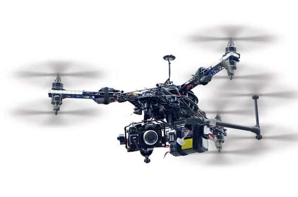
The Best Multi Rotor Ag Drones
A multi rotor drone is a better choice for close-in scouting, spotting and detailed surveying tasks than a fixed wing drone.
Flying a multi rotor drone, low and slow, gives you far more control over every image you shoot. As a result, accuracy and resolution are often better than fixed wing UAVs can deliver.
The tradeoff, of course, is you have far less range and coverage per flight. Most multi rotor ag drones can’t cover more than 50 acres between charges / battery swaps.
PrecisionHawk Crop Scouting Package ($1,989)
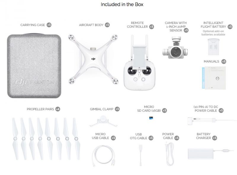
PrecisionHawk sells a starter-level quadcopter package that includes a Phantom 4 PRO with included visual sensor, DataMapper Lite image processing software (1 year subscription including a few VIS-data algorithms), InField flight monitoring software, and InFlight flight control and monitoring mobile app that allows you to control the aircraft using your smartphone.
The Phantom 4 PRO is an excellent camera drone that is more than capable of most visual surveying tasks; but, there are additional costs to turn this package a complete crop surveying solution. And, it has its limitations.
For example, it has no multispectral sensor to capture NDVI data, and you’ll probably need to purchase additional Datamapper algorithms to extract value out of the images you shoot.
LEARN MORE AT PRECISIONHAWKSentera NDVI Upgrade for DJI Phantom 4 PRO (about $2,000)
This is a great starter ag drone, especially for scouting.
Sentera sells a TrueNDVI camera upgrade for DJI’s wildly popular and easy to use Phantom 3 and Phantom 4 quad copters. They’ll also sell you a new Phantom 4 PRO, fully equipped.
The kit integrates a 1.2MP NIR global shutter camera alongside your existing Phantom camera, so you get the best of both worlds — a fully-gimbaled color camera for scouting, plus NIR photos for NDVI indexing.
Photos are geo-tagged and timestamped to enable quick, streamlined field scouting and identification of problem areas.
The package includes a free version of Sentera’s AgVault image processing software.
Two downsides, though: you’ll have to ship your Phantom quad to Sentera to perform the upgrade; and, attaching a second camera voids DJI’s warranty.
LEARN MORE AT SENTERADJI Smarter Farming Package ($8,300)
DJI’s Smarter Farming package is an affordable and easy-to-fly ag surveying solution for professional ag service providers and serious farm operators.
Unlike PrecisionHawk’s Crop Scouting Package, this rig is a proper multispectral agriculture surveying platform.
And, unlike Sentera’s bolt-on NDVI camera, DJI’s warranty remains intact.
The DJI Smart Farming Package includes their easy-to-fly Matrice 100 flying platform with two onboard sensors (visible and NDVI) installed.
For image processing, the package comes with PrecisionHawk’s excellent DataMapper solution.
Everything is integrated, tested and ready to got to work, out of the box.
LEARN MORE AT DJIAGCO Solo ($7,850)
Based on the 3DR Solo quadcopter, the AGCO SOLO add-on kit includes a GoPro Hero 4 camera for color imaging and a GoPro near-infrared camera for monitoring plant health.
This UAV also includes one year of Agribotix imaging software. The package produces high-resolution orthomosaics, NDVI maps, and Field Health and Management Zone maps. Useful flight time is about 20 minutes.
LEARN MORE AT AGCOSentera Omni Ag ($16,995)
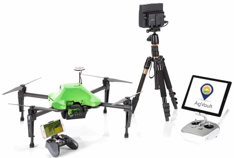
Using Sentera’s Double 4K multispectral sensor, the Omni Ag is a completely integrated hardware + software package that captures high resolution RGB visual, NIR, NDVI and Live (streaming) NDVI data – all at the same time.
Uniquely, the Omni Ag drone can stream live NDVI crop data as it flies, which means you get instant feedback on crop health and can take action before it lands. I don’t know of any other quads that can do this, right now.
The Omni Ag drone can be controlled by your smartphone or the dedicated flight controller.
Image processing is handled using Sentera’s AgVault 2.0 software.
LEARN MORE AT SENTERAOther Multi Rotor Ag Drones
- senseFly eXom: the eXom is a quadcopter developed by French drone manufacturer, Parrot, specifically for agriculture applications. This package includes an image processing pipeline based on Pix4D’s popular cloud-based solution.
- AgBot by Aerial Technology International ($8,000+): ATI’s package offers IR, Multispectral and HD video modules (quick release/swappable); 26-minute flight time; 16 mile range; rugged carbon fiber chassis; 1 fps data capture @ 38mph
- InDago AG ($30,000+): built by Lockheed Martin, the InDago can stay aloft for 45 minutes and cover 75 acres per flight, about double that of any other quadcopter.
Ag Drone Service Providers
There are thousands of drone operators in the US today, and about one-third claim to offer services useful to farms.
With the FAA’s new regulations, which allow for new pilots to get their remote pilot certificate by simply taking a written test, no doubt thousands of new operators will soon be hitting the market.
But that doesn’t mean they know how to fly safely. Nor does it mean they know how to shoot orthomosaic images for your farming operation.
Here are experienced & certified drone operators and image service providers that serve agriculture businesses:
- Empire Unmanned (ID): Empire was the first ag drone service to receive a 333 exemption in the US. Robert Blair is one of the principals and is one of the most knowledgeable speakers on using drones for precision agriculture.
- Vine Rangers (CA): this Northern CA service provider specializes in servicing wine growers.
- AeroHarvest: Like Vine Rangers, this CA company serves vineyards with leak detection and optimizing irrigation schedules.
- AgWorx: A specialist in precision agriculture from Raleigh, NC. that handles everything from harvest timing to software applications for data collection on the ground and in the air.
- Digital Harvest (formerly BOSH Precision Agriculture): This Newport News, VA, business specializes in collecting images, processing data and producing useful agricultural informatics.
- Leading Edge Technologies: Based in Winnebago, Minnesota, Leading Edge converts drone data into farm intelligence for applications such as grain management and other precision agriculture solutions.
- PrecisionHawk: This startup from Raleigh, NC, is creating an algorithm marketplace to help interpret and correlate data collected from satellites and drones. They also manufacture the Lancaster fixed wing drone and supply DJI with ag-specific add-ons. A leader in the industry.
- Trimble Navigation: Aside from its massive GPS business, this Sunnyvale, CA, outfit offers many applications for precision ag, from yield monitoring to water management.
- Wilbur-Ellis: This $3 billion farm equipment supplier is working to bring satellite and drone imagery to AgVerdict, its software platform for agronomists.
- Measure32: This full-service drone operator provides image survey and processing for a wide range of industries, including agriculture. They operate over 300 drones and UAVs for business purposes.
For a larger collection of agriculture drone manufacturers, analytics and service providers, check out the list below:
| Company | Product/Service | Location |
|---|---|---|
| Ag Drones & Sensors | These companies manufacture the most popular UAVs and sensors used in smart agriculture operations worldwide. | |
| AgEagle | Data acquisition drones for precision agriculture. | United States |
| American Robotics | Drone developer specializing in agricultural automation. | United States |
| DJI | Popular flying platforms, sensor packages and software for aerial crop surveying | Hong Kong |
| PrecisionHawk | Drones, sensors and software for businesses to manage and monitor their assets. | United States |
| Sensefly (Parrot) | Drones for collection and analysis of geospatial data including an aerial crop analysis system. | Switzerland |
| Sentera | Precision ag drones, sensors and software. | United States |
| Skycision | Solution for crop stress detection and analysis of agricultural operations using drones. | United States |
| Presticide-Spraying | These UAV manufacturers sell drones designed to carry and spray pesticides and other liquids. | |
| Airboard Agro | The first agricultural drone with a 100 liter capacity for industrial pesticide and fertiliser spraying. | United States |
| DJI | DJI Agras series of Agricultural Drones, a popular 8-rotor multicopter designed to spray pesticides and liquids | Hong Kong |
| HSE | 11 models of agriculture UAV crop dusters sprayers, 6 helicopters and 5 multi-rotor UAV crop dusters. | United States |
| Skyx | Drone systems for crop spraying. | Canada |
| Rantizo | An easy-to-use drone spraying platform that precisely applies inputs where and when needed. | United States |
| Aerial Imaging & Analytics | These aerial imaging providers use their own equipment and charge you by the acre to provide sensor and image data. | |
| AGERpoint | Capture precise agriculture data using LiDAR enabled drones. | United States |
| Agribotix (AgEagle) | Drone-enabled precision ag solutions. | United States |
| Aerobotics | Early pest and disease detection solution guided by drone and satellite imagery. | South Africa |
| Astro Digital | Global satellite imaging and analysis company. Uses nano satellites to capture images in visible and infrared spectrum. | United States |
| Ceres Imaging | Data-as-a-service (growers pay by the acre) aerial spectral imagery company that uses low-flying planes | United States |
| Deveron | Drone data company focused on agriculture operating in Canada and the United States. | Canada |
| FarmShots (Syngenta) | Detects diseases, pests, and poor plant nutrition on farms by analyzing satellite and drone imagery. | United States |
| Gamaya | A farming management solution using hyperspectral imaging and data analysis. | Switzerland |
| Hummingbird | Artificial Intelligence business that provides advanced crop analytics to farmers. | UK |
| Mavrx (Taranis) | Spatial analytics platform using UAVs, aircraft, and satellites to help growers maximize yields and reduce costs. | United States |
| TellusLabs (Indigo Ag) | Combines historic satellite imagery and machine learning to map and predict agriculture supply chain. | United States |
| Smart Farm Technology | If you operate your own UAV fleet and would like to use your data to manage your farm, use one of these applications or services. | |
| Cainthus | Uses machine vision technology to monitor the health and well-being of crops and livestock. | United States |
| FluroSat | Uses satellites & drone imagery to predict disease and help growers make decisions. | Australia |
| Resson | Farm analytics solution uses drones, in-ground sensor data and machine learning to create insights. | United States |
| Slantrange | SLANTRANGE uses custom sensors, drones and analytical tools to inform farmers about crop health. | United States |
What Is Precision Agriculture?
Precision agriculture is a farming management concept based on observing, measuring, and responding to inter-and intra-field variability in crops.
The goal of precision agriculture is to more efficiently apply a farm’s limited resources to gain maximum yield. A primary method for doing that is to minimize the variability of crop health within and across fields. To learn more about precision agriculture, read this excellent overview published by The Economist.
Due to its nature, precision agriculture requires a LOT of data to work. The three main types of data include:
- geo-tagged images: visible and multi-spectral aerial images taken of fields, over time; this is where drones play
- equipment performance: real-time feedback & logs provided by sensor-equipped manned and unmanned equipment such as seeders, spreaders, tractors and combines
- management data: crop yield and other data provided by farm operators
The use of precision agriculture technologies is growing very quickly, globally, according to Technavio.
Where Do Drones Fit in Precision Agriculture?
Drones are really just a new, high-precision way to obtain geo-tagged images from the air.
Compared with other aerial survey methods, drones generate more precise and more frequent data about the condition of crops. This data is used in many ways to improve the performance of a farm’s operation.
For surveying fields of less than 50 hectares in size, drones are cheaper than manned aircraft surveillance, manned scouting, and satellite imaging.
Some claim that the new FAA rules will restrict the usefulness of drones for agriculture because, under the new Part 107 rules, all observation and measurement must be taken by a drone that is within the visual line of site (VLOS) of the operator. This becomes a real issue for fields and farms that are bigger than VLOS.
But the vast majority of farms don’t have this problem.
According to this report, there are approximately 2.1 million farms in America. The average size is 434 acres. Small family farms, averaging 231 acres, make up 88 percent, meaning that 1.85 million farms can benefit immediately from ag drones.
Drones are used to gather a variety of image-based data about the condition of crops, fields, and livestock – including:
- plant height
- plant count
- plant health
- presence of nutrients
- presence of disease
- presence of weeds
- relative biomass estimates
- 3D / volumetric data (piles, patches, holes and hills)
For livestock operations, drones can be used to monitor the location, status and movement of animals over time with more frequency and at a lower cost than other means.
Drone data is used to do farming jobs more effectively and efficiently, including:
- Crop Scouting – replace men with drones
- Crop Health Monitoring – biggest ROI, by far
- Field Surveying/Scouting (before planting)
- Nitrogen Recommendation
- Yield Monitoring
- Plant Stress Monitoring
- Drought Assessment
- Senescence Analysis
- Leaf Area Indexing
- Phenology
- Tree Classification
- and more
To take quick action, orthomosaic images generated by drones can be fed into an agricultural program like SMS by Ag Leader, SST Summit®, FarmRite®, Stratus®, Sirrus®” or other software tools to create prescription maps.
Prescription maps inform the farm operator where & what specific actions are needed, such as increasing or decreasing nitrogen spread on trouble spots. Prescription maps can be transferred directly into a precision applicator (sprayer) like a John Deere® or Case IH®.
Here’s a great 7-minute video segment produced by Iowa Public TV that explains why more and more farmers are incorporating drones into crop management.
Drones & Agronomy Management Systems
Because of the amount of data required, many precision farmers use agronomy management systems to collect and integrate all of the data flowing to/from their sensor-equipped tractors, combines, drones and other equipment found on farms today.
Leading agronomy management platforms include AgOS by AgWorks and MyAgCentral.
Drones interact with agronomy management systems by feeding them with rich, detailed and timely geo-tagged images. Using this data, farmers can react more quickly and more precisely than they can using other aerial imaging methods.
Drone Advantages Over Other Aerial Imaging Systems
By some measures, 80% of the global drone industry revenues are related to agriculture, in some way.
But why would farmers – some of the most risk-averse people on Earth – adopt such a new technology?
Perhaps it’s because agriculture drones offer clear advantages over other crop monitoring methods including satellite imaging, manned scouting, and manned aircraft. These advantages include:
- Cheaper Imaging: for fields less than 50 hectares in size, drones are considerably less expensive than satellites or manned aircraft surveillance.
- Greater Precision: drone cameras take centimeter-level images that reveal much more detail about a crop’s condition.
- Earlier Detection of Problems: because drones survey more frequently, weeds, pests and other abnormalities are detected earlier.
- Total-Field Scouting: instead of riding an ATV around the perimeter to scout perhaps 5% of a field, now every field can be scouted 100% using drones.
- 3D/Volumetric Data: drone images can be used to calculate the volume of piles, holes, hills and patches. These can be compared to Infrared images to detect density issues like hot spots in a crowded beet field, or to identify contour problems such as north slope shade issues.
- More Frequent Index Reporting: drones offer a cost-effective way to monitor crops more frequently for key indices like CCCI (canopy chlorophyll content index), CWSI (crop water stress index) and NDVI (normalized difference vegetation index).
In day-to-day operations, these advantages help farmers catch problems faster and react more quickly, which can save thousands of dollars in crop losses per field.
Long-term, the data generated by drones help farmers gain a more accurate & detailed picture of how their crops are reacting to their management strategies, which can lead to more effective use of limited resources.
After all, a typical family farmer only gets 40 chances (seasons) to get things right… every extra bit of knowledge helps!
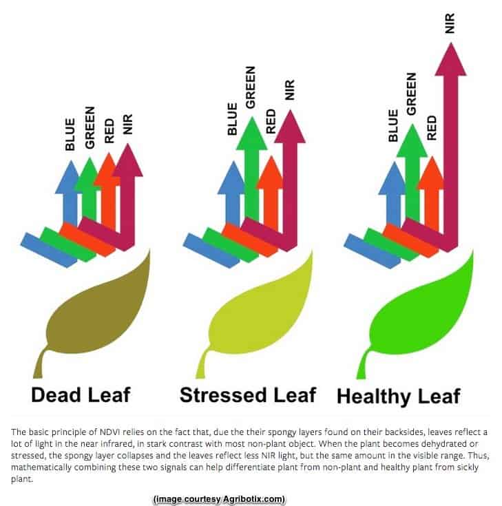
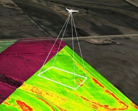
How Flying Cameras Measure Crop Health
Most agriculture drones depend on multi-spectral imaging to spot problems with a crop’s health; specifically, they look at changes over time in visible light (VIS) and near-infrared (NIR) light reflected by crops. These images are taken over time by drones, manned aircraft or satellites.
It is possible to detect plant health from these images because plants reflect different amounts of visible green and NIR light, depending on how healthy they are. By measuring the changes in visible and NIR light reflected from a crop, we can spot potential health issues.
This image explains the general idea:
To monitor changes in plant health over time, drone images are processed to calculate a tracking index called NDVI (normalized difference vegetation index), which is a measure in the difference between light intensity reflected by the field in two different frequencies:
NDVI is the ratio of near infrared (NIR) reflectivity minus visible red reflectivity (VIS), divided by NIR plus VIS:
NDVI = (NIR-VIS)/(NIR+VIS)
Here is what you see when you compare a normal camera image of a winter wheat field to a NDVI-processed image of the same field:

Notice how the NDVI-enhanced image (right) does a great job separating the healthy wheat stalks (green) from dying edges (red) and the dry earth (black/brown).
There is some debate over whether NDVI is the right index or whether the simple difference between light spectrums (NIR – VIS) is more useful. Agribotix put together a great writeup on this debate and the misconceptions re. what NIR spotting can and cannot do today.
NDVI is the most popular index calculated using drone data, but there are many others. Some may be more or less important to your farm, depending on your situation. Some of the more popular indices include:
- CWSI (crop water stress index): measures temperature differentials to detect/predict water stress in plants. Requires a thermal imaging sensor and the use of a nearby weather station.
- CCCI (canopy chlorophyll content index): detects canopy nitrogen levels using three wavebands along the red edge of the visible spectrum. Requires visible and near-infrared cameras.
If you want to dive deep into this emerging science of agriculture image processing, here’s a list of the latest research.
First Decision: Fixed Wing or Multi-Rotor?
Fixed wing drones like the AgEagle RAPID, PrecisionHawk Lancaster and SenseFly eBee SQ are often preferred by farmers because they can cover more area and spend more time in the air than a multi-rotor platforms like the DJI Phantom 4.
That said, they can’t do everything and are best suited for large, open-field scanning.
Fixed wing drones often carry more payload than a multi-rotor – which means more sensors – so more information can be captured in a single flight. This can reduce the total time to collect data for a given acre.
Fixed wing drones are more expensive, too – they typically cost $5,000 to $25,000 or more, after being fitted with sensors.
Multi-rotor ag drones like DJI’s Matrice 100 are better-suited to precision imaging of small/constrained areas and 3D scanning of fields and objects, due to their maneuverability.
Flight times for quads and other multi-rotors are about 1/2 that of a fixed-wing drone.
Payloads on many multi-rotors are less than fixed wings, so most only carry one or two sensors. As a result, covering an entire field can take twice as long as with a fixed-wing.
Multi-rotor drones are generally cheaper than fixed wings, starting at around $1,500-$10,000 for a professional-grade camera drone packaged with multi-spectral cameras and software for agriculture image processing.
The Best of Both Worlds
Rather than opting for one type of drone, some farmers and operators purchase less expensive versions of both.
A fixed-wing drone is used for large open spaces where long, unobstructed straight-line passes are possible; and, a small inexpensive multi-rotor is used for spot-checking trouble areas more closely, for quick scouting missions and for handling area a plane cannot fly over.
Lots of farmers today start by buying a ready-to-fly $1,500 quadcopter like a Phantom 4 PRO or an NDVI-equipped pre-tested solution like DJI’s Smarter Farming Package.
After testing the ROI of drone surveying, they may upgrade to the more expensive and more efficient multi rotor and fixed-wing packages that can integrate with their Farm Management Information Systems (FMIS) and Agronomy Management Systems (AMS).
Capturing The Data: Imaging & Sensors
There are many choices of imaging sensors available today for agriculture drones. Options range from $200 for a GoPro HD camera to well over $50,000 for a hyper-spectral camera.
Cameras
The most common and cheapest type of sensor is a high-resolution camera, which takes visible wavelength images (VIS). Several of these cameras can also take near-infrared images (NIR) when equipped with the right filters.
The minimum image resolution required for agriculture applications is 12 megapixels, which popular drone cameras such as the GoPro Hero 3 and Hero 4 are capable of capturing.
In contrast to what most photographers will tell you, you want a camera with a wide-field, wide-angle or “fish-eye” lens, as these lenses tend to capture more area in a single shot. Don’t worry about the image distortion – quality image processing software eliminates this during processing.
Some of the more popular cameras used in agriculture today include:
- Sony QX1: compact, lightweight mirrorless camera takes 20 megapixel high precision Images in RAW and JPEG. VIS images only.
- Canon EOS Rebel SL1 DSLR Camera Kit: captures VIS images only.
- Zenmuse X7: Gimbal and camera system used on DJI systems. VIS images only.
- GoPro Hero: lightweight and weather-proof, GoPros are used on lower-cost quadcopter drones. The Hero probably the most popular ag camera in use today. VIS images only.
- MaxMax offers a line of Nikon, Sony and other model near-infrared (NIR) cameras priced from $500 to $5,000. NIR and VIS versions.
Multi-Spectral
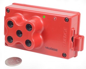
Multi-spectral imaging sensors allow you to see things you cannot see in the visual spectrum, such as wet patches on the ground.
The MicaSense Red multi-spectral sensor (shown above) lists for $6,450.
Another option is the Sentera NDVI upgrade for the DJI Phantom series drones. This is a new ultra-lightweight NDVI sensor for Phantom 3 and Phantom 4. The DJI gimbaled camera is not modified. It captures visual-band (VIS), near-infrared (NIR), and NDVI data together during a single flight.
Thermal
Airborne thermal sensors can see hotspots and measure changes in land and plant temperature over time.
Thermal sensors can also detect the presence of water due to its cooling effect, which can be helpful in spotting crop damage due to drought and/or seasonal issues.
LIDAR
LIDAR is a precise remote sensing technology that measures distance by illuminating a target with a laser and analyzing the reflected light. LIDAR is commonly used to measure buildings and land masses with precision, and to develop an accurate 3D model of an area.
LIDAR sensors are very expensive, often costing $60,000 to $150,000.
Surveying Crops By Drone: The Process
Whether you use a fixed wing or a quad to survey your fields, the process of gathering useful data with a drone consists of 4 basic steps, as follows:
1. Plan Your Flight
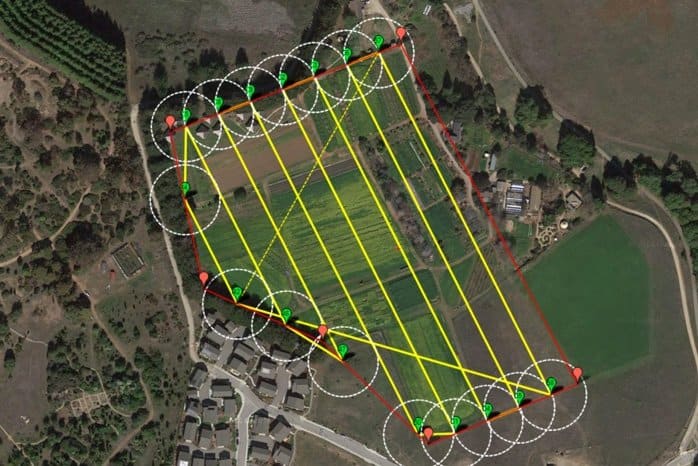
Many of the latest agriculture drones come with flight planning software that lets you to draw a box around the field you want to survey (on a Google Earth map or similar), and a flight plan will be created for you automatically. Some even plan the camera shots for you, automatically.
Then, you upload the flight path into your drone and get ready to fly.
If you are using a home-built platform or an older ground control station, then you may need to manually code or set each turn point.
2. Fly & Shoot
With your flight plan loaded and drone armed, it’s time to start flying – and shooting images.
With a fully-integrated system like the PrecisionHawk Lancaster, this part is easy.
Basically, you just send the drone on its way and the system will automatically take images using the onboard camera and sensors as the drone executes its flight path. The drone will use GPS location to trigger each shot.
After finishing its run, the drone lands automatically (usually all goes well). Easy!
If you don’t use a completely integrated drone package, then one person will need to take the shots manually while a GPS autopilot or another pilot flies the aircraft.
If you are manually shooting your images, please bear these points in mind:
- to capture high resolution data correctly for ag purposes, your images need to overlap with each other by at least 70%
- shoot images based on GPS location, not time, to ensure you get the image overlap and the coverage needed
3. Process Images
The most challenging part of the agriculture drone surveying process is translating the hundreds of high-res images you just captured into information you can actually use. But don’t worry, it’s not that hard to do (or learn).
Most farm drone operators need to process hundreds of visual, thermal and multi-spectral images per flight, to identify changes in crop health over time or to spot anomalies.
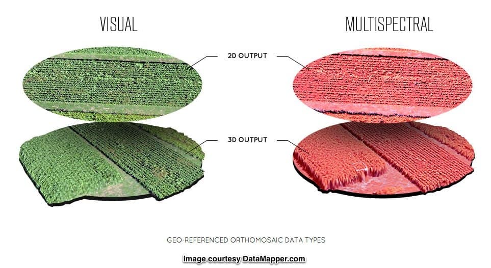
All of these images need to be stitched together, converted into orthomosaic 2D images, processed and analyzed for you to get useful information from the flight.
That’s a lot of data processing. And your home PC probably isn’t up to it.
This is where image processing software and services come in.
Popular Image Processing Software for Agriculture
Most agriculture drone operators use the following tools to turn aerial images into useful data. All of them use cloud-based processing to take the load off of you:
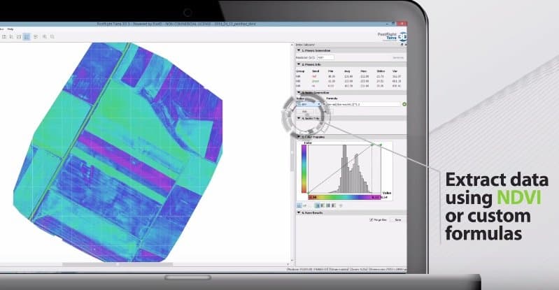
- Pix4D: this popular & expensive image processing platform converts a series of aerial images into 2D orthomosaics, 3D point clouds and 3D mesh models. Pix4D can also calculate NDVIs, DVIs, SAVIs and custom indices as needed. To use Pix4D, you upload your images, let them process, then receive your reports and visuals typically within minutes to a few hours. Pricing is $350 per month to rent or $8,700 to own.
- AgEagle’s RAPID
- senseFly’s Postflight Terra 3D: based on Pix4D, this is senseFly’s software for converting aerial imagery into 2D orthomosaics, 3D models, and differential indices. Terra 3D is provided free with all eBee drones.
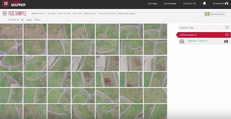
- PrecisionMapper by PrecisionHawk: now called Data Mapper, this is a cloud-based application that gives anyone the ability to upload, store, process, and share their aerial image data. Works with some, but not all, UAS platforms.
- Trimble: designed for professional land surveyors, Trimble’s Photogrammetry Module office software to create detailed orthophotos, digital elevation models, point clouds, volume calculations and 3D models. Trimble’s general-purpose Inpho UASMaster Module can be used for advanced photogrammetric processing.
- DataMapper by PrecisionHawk: a 100% cloud-based platform that supports image capture, differential processing and algorithmic analysis for many industries. Their unique Algorithm Marketplace lets you pick & apply specific algorithms to extract useful data such as NDVI, DVI, plant counts, scouting reports and more.
- Correlator3D™ by SimActive: advanced photogrammetric processing client software for use on high-end PCs. Several aerial survey firms such as AeroVironment use them. Performs aerial triangulation (AT) and produces dense digital surface models (DSM), digital terrain models (DTM), point clouds, orthomosaics and vectorized 3D models.
Some image processing platforms are proprietary to the flying hardware you’re using, and others are general purpose tools that anyone can use. General-purpose packages like Pix4D tend to have a bit of a learning curve.
Image Processing Services for Agriculture
If you don’t want to operate the software yourself, you can upload your data to a data processing service who will generate the reports for you.
4. Review & Take Action
Now that you’ve downloaded your reports and enhanced images, it’s time to see what’s up with your crops.
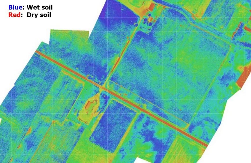
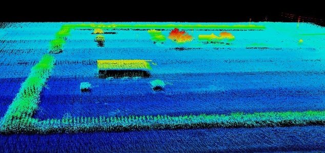
Perhaps you’ll see issues your scouting crew couldn’t see from the ground:

Or, maybe you’ll find a problem with water retention after the latest storm:
Or, perhaps you’ll uncover new trouble spots in your corn fields that need a bit more nitrogen:
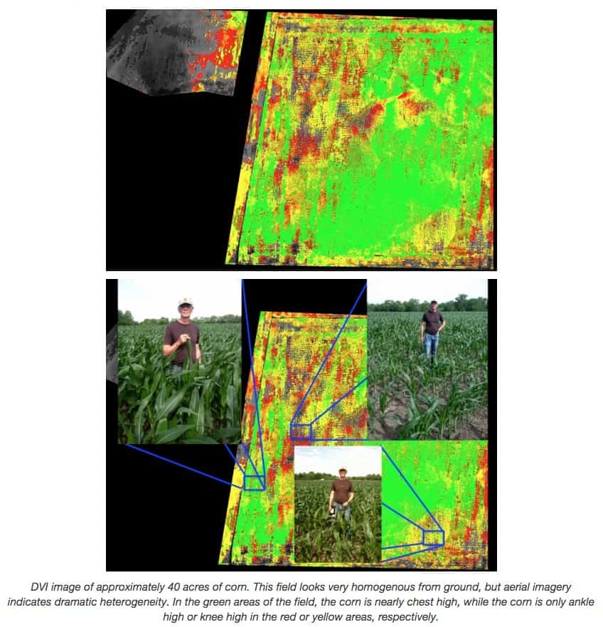
Whatever you find, after you’ve reviewed the health of your crops you can input the data into one of several farm management systems like MyAgCentral to improve your overall view of the farm’s health and operational status.
And take action.
How Much Does It Cost To Survey My Farm?
Agris Co-op Ltd. in Chatham, Ontario is one of the first precision ag drone imaging service providers to enter the Canadian market.
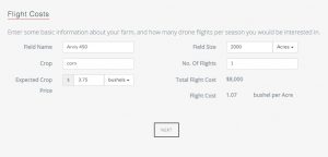
Using fixed-wing eBee and Swinglet drones, the firm shoots high-res NDVI images of corn fields in Ontario for a price of about $5 an acre. A single flyover covers 100 acres in 15 minutes, capturing about 300 images for a price of $500.
This compares to a cost of about $1,500-$2,000 for satellite or manned aircraft photography of 100 acres, or $15-20 per acre; and, both these older methods yield less resolution, can be hampered by cloud cover, and take more time to process the images.
On a single day, Agris can cover more than 1,000 acres using a single drone. Images are post-processed in about 2 days.
For another custom full-service cost estimate, check out the nifty Drone Service Cost Calculator on Measure.aero’s website.
Drone Insurance
For any commercial activity, it’s a good idea to insure yourself against property damage, liability and lawsuits.
All you need to do is search “drone lawsuit” to prove it’s worth getting insured.
At Interdrone 2015, Scott Smith of SkySmith shared this example of what it costs to unsure a $20,000 drone (about the cost of a PrecisionHawk Lancaster):
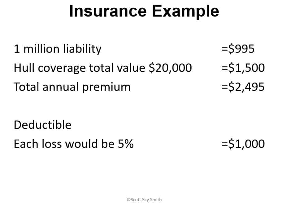
To learn how to find insurance for an agriculture operation, read our buying guide, Drone Insurance: Where To Buy It & How Much To Get.
Options and Upgrades
Without going into detail, you should be aware that some of your system’s components can be upgraded or replaced if you don’t like what you’re currently using.
The most common components upgraded include:
- Ground Control Station
- RC Controller
- Sensors
- Props
Avoid changing image processing tools and services that have been designed with your hardware in mind. Something to think about when selecting your first drone.
Common Issues and Concerns
Flying a drone for agriculture involves many of the same issues facing consumer and other commercial drone operators. But there are a few gotchas unique to agriculture, especially when it comes to data and the EPA.
Privacy Laws
There’s a lot of noise in the media today about camera drones taking photos of people without their knowledge. Shotguns have been used to settle the score.
While this could happen on a farm, it’s unlikely.
Nevertheless, your neighbor’s home and fields are their property, and taking unauthorized images of them could violate local or state privacy laws. And state legislatures are on fire, when it comes to drones.
Nineteen US states (Arkansas, Florida, Hawaii, Illinois, Louisiana,Maine, Maryland, Michigan, Mississippi, Nevada, New Hampshire, North Carolina, North Dakota, Oregon, Tennessee, Texas, Utah, Virginia and West Virginia) have passed legislation. 6 other states have adopted resolutions.
In 2015 alone, 45 states have considered 156 bills related to drones.
So: make sure you check with a local lawyer to get the latest rules in your region.
Connectivity and Bandwidth
Millions of acres of farmland in the US have little to no online connectivity or cell coverage. If this includes some of your fields, then you need the ability to store captured images & data locally – in the drone or on a nearby ground station – and then upload them later on, when you get back to the office.
Systems such as AgOS by Agriworks operate under the assumption you may not have connectivity at all times.
Don’t choose a drone that requires a live connection to the internet to capture data; it just isn’t a good choice for agriculture.
Data Ownership
The image data generated by agriculture drones can be really useful for lots of people other than farmers.
The EPA, county officials, drone operators, land surveyors and land management officials can get a tremendous amount of value from your geotagged images – if they have access to them.
Some organizations can also do damage to a farm if they have access.
For this reason, ownership of data is a critical legal issue that needs to be dealt with upfront, via contract, whenever you:
- hire someone to perform an aerial survey of your farm
- process your images through a third party (software or service provider)
- share or commingle your images with a third party
By default, the farmer/land owner should always retain full ownership of all data generated by drones flying over his/her property. Then, via contract, these rights can be granted to third parties on a need to know, exception basis.
Bottom line: you never want a third party to own your data.
FAA Regulation & Operator Certification
Flying drones for agriculture is always a commercial operation, according to the FAA.
By law, your drone operator must have FAA operator training and have their remote pilot certificate before they can operate a drone over your land.
If they are not properly certified to fly an unmanned aircraft, then you should not hire them nor let them operate a drone over your property – even if no money changes hands.
EPA Regulations
By law, the EPA has the right to access any and all data generated by drones flying over your property.
There’s nothing you can do about this. For this reason, data retention and storage policies are important to pay attention to.
Interference With Other Aircraft
Crop spraying and other manned aircraft may share the same airspace as an agriculture drone.
For this reason, it is important to file a flight plan with your local airport/FAA office before every drone flight.
Make sure your drone operators understand this, too.
Get Your Contracts Right
If you are a new agriculture surveyor or drone operator, then you need professional legal help when setting up your contracts to deal with the issues above (and more). DroneLaw.Pro offers operators contract templates, training videos and a unique “Ops In A Box” business setup kit.
If you operate a farm and are interested in hiring a drone surveyor, then make sure you know what a good contract looks like.
We’re Still In The First Season…
Little known fact: Japan has been using unmanned aerial drones for over a decade, in rice farming.
But in the US & Canada, agriculture drones are very new.
In fact, the first FAA exemption for a precision agriculture drone operator was only awarded in January of 2015.
And according to that operator, Empire Unmanned, only 5-10% of farms are using drones in their precision agriculture operation.
If you have any questions or comments about this buyer’s guide, please leave them below in the Disqus comments section.
Good article, but got a few things wrong:
– Check HoneyComb’s price again (somewhere around $20k)
– I know it’s your opinion, but in the top 3 fixed wing drones you have the Trimble UX5. Did you take price into account? $53k is much more than any other fixed wing
– Didn’t research AgEagle much, don’t understand the processing of DroneDeploy
– Not so sure that Wingscan is still a thing. I think they broke up and the hardware is now Sentera and the software is Aglitix
I know you have the right, but the article is a bit biased (PH)
Thanks for your feedback, Brian.
Good catch on Wingscan >> Atlasoft. I’ve update the article.
HoneyComb’s AgDrone starts at around $15k, but it’s easy to drive the price higher.
Re. the UX5: I’m just trying to offer the best in a range of prices.
Re. bias: putting a list like this together is tough, with all the choices out there. I have no relationship to any ag drone manufacturer, fwiw.
Which drones would you add/delete from the list & why?
With the exception of the eBee, all the multirotors listed are just consumer level drones and are really not suited for field work. There are sUAS that are built for and dedicated to agricultural like the ATI AgBOT which is fully integrated with the MicaSense RedEdge for NDVI mapping and other applications. http://www.aerialtechnology.com/ati-announces-agbot-uas-updates/
Thanks John.
I agree; on the other hand, a lot of farmers today use the cheaper RTF drones to learn.
May I ask: do you have a professional relationship w/ ATI (indep. sales rep, works for them, etc.)?
Hi Andrew,
Apologies, I do work for ATI and should have mentioned that. There are a number of other drone companies like Aerialtronics and Draganfly that also make ag specific machines as well. I understand the need for entry level systems and wasn’t detracting from the Solo of Phantom, but the quality of data will general reflect the low price point.
Andrew,
I guess I should rephrase my response. I think you have all of the companies that are making an impact for agriculture, just a few phrases I misunderstood. Well written article! For some reason you wrote quite a bit about the PrecisionHawk, but maybe it’s because they have the most information available!
Thanks again
Good product marketing has its advantages 😉
I’m looking at using drones commercially selling my services to other farmers. Is this possible? Also what do I need to do first to be able to do this?
In addition to a suitable drone + multi-spectral camera setup, you will need:
1. a commercial pilot’s license (~$7,000)
2. Sec. 333 exemption from the FAA ($100s for the legal fee)
3. training on how to fly your class of drone – probably fixed wing & quads (online courses exist; contact mfr of drone)
4. training re. how to properly take multi-spectral images (online or in-person course)
5. training re. how to process the images using software, to extract useful information (get from the software company)
6. an understanding of the laws that apply to ownership of data/images (self-learn)
The FAA says you will soon be able to get a lower-grade “drone operators license” instead of a full pilot’s license, but they haven’t finalized those regulations yet.
The best way to learn is to talk to someone who currently does this for a living. Recommend you reach out to Robert Blair at Empire Unmanned (ID): Empire was the first ag drone service to receive a 333 exemption in the US. Great guy, knowledgeable, easy to talk to.
Hi Andrew! An easy “hack” being used by us small UAV businesses is to get a Hot Air Balloon Operators License which can vary in price, but can be has for as low as $3k. The 333 exemption can be done via templates which are free everywhere with a simple google search (google FAA 333 exemption template). As for the drones themselves I purchased my fixed wing (covers 600 acres on one charge) and my hexacopter for $2k as you just need to know where to look. Hint: RCGROUPS.com Classifieds section.. Hope this helps those who need it!
DREi
SkyAerialSolutions.com
Thanks DREi ! Great tips.
That’s a great idea!
Thanks Andrew. I’ll contact him. Greatly appreciated!
Hi Andrew
great article!!, a lot of answers about the subject.
If you got a clue?
I would like to know who buy this drones and where? small framers? big farms? Corporations?
How many of them really get something out of it?
Thanks
Amit
Farms all over the world use drones today to survey crops and cattle. In terms of sheer $$, agriculture is the single largest industry employing drones and drone operators in the world today. Everyone from small, family-owned farms to ginormous corporate farms are using them or experimenting, right now.
About 5% of farms use some form of UAV/drone aerial surveying today, according to a couple of experts I saw at a recent Las Vegas drone conference.
Most farm owners purchase an aerial crop surveying service from a precision agriculture outfit that is approved and certified for flying commercial drones. See our list of top ag drone operators, above, for examples.
Some farmers skip the middlemen to buy drones directly and fly them to survey their own crops.
The benefits in terms of precision, coverage and cost savings are very real, but I don’t think anyone knows how many farms are improving crop yield due solely to drone-based aerial photography. Usually, drones are used in conjunction with a broader precision ag system that includes lots of other parts.
Hope this answers your question. Thanks for the compliment 🙂
Hi Andrew
Thansk a lot for your article. Very Helpful.
Reviewing 3DR SOLO specifications, is very useful because it can adapt to different cameras.
For this drone, which camera within which you recommend I can integrate and which includes NIR (because I need images in the visible and images for calculating the NDVI)?
Thanks.
Camilo
Camilo,
I agree w/ you about the openness of the 3DR software platform, it’s perfectly suited for customization.
Sentera makes a series of NDVI sensors that are lightweight enough to fly on the Solo, Phantom 4 and most other light-commercial UAVs: https://sentera.com/sensors/
Hi Andrew and thank you for all the precious info!!
I wanted to ask you if you know how to chronologically order the different products.
I’m working on my thesis and it’s quite crucial to have a timeline of the UAVs that have been released and actually work.
Thanks in any case!
Luca
Luca,
Sorry, but I don’t know the release dates of all of the UAVs in precision agriculture.
Thank you anyway for your time!
Since you seem so kind may I ask you another question?
Maybe is not your business, so of course you could reply that you have no idea.
I’m not an expert at all about UAVs, but I have to study them for my final thesis and in particular I have to see how this technology is evolving with respect to different application fields.
So my question is: as regards mapping functions of drones I was wondering if there were big differences in terms of tools (cameras,…) and softwares (image processing software,…) when “moving” towords different application fields like from construction to agriculture or infrastructure monitoring.
I’m asking that because for instance in analyzing eBee and eBee Ag I’ve noticed that apart from the name there are almost no differences.
Maybe I’m wrong and there are additional cameras required for understanding certain aspects of land if we’re talking about agriculture.
I hope I was enough clear and I thank you so so much.
Luca
Luca,
The answer is: it depends on your specific need/application.
For single-sensor imaging applications – visible light, infrared and NDVI – many of the popular multi-rotor and fixed wing drones can be used in many industries, including ag. This is because the cameras and sensors for these applications are light enough to be carried the popular platforms. And, the most popular drones are sophisticated and programmable enough for most applications.
But when you need to carry 2 or 3 sensors at the same time, or a heavier sensor pacakge like LIDAR, the payload requirement can force you into a more expensive flying platform. At that point, many customers turn to niche / specialized drone manufacturers and industry-specific system integrators for their UAVs. There’s often more software/system integration work involved when you use a niche platform, however.
Software & data quality also play important roles in which UAV you choose. If you are heavy into precision ag, for example, then you may want a platform that is tightly integrated with your agronomy management system(s). Or, you may want to outsource your surveying to an integrated service provider like PrecisionHawk, who can simply deliver your data as a service. In this case, they choose the platform.
In general, the trend seems to be that the most popular UAV manufacturers, DJI, 3DR, Yuneec and Parrot, are encroaching into or providing solutions for more and more niches/applications. 3DRobotics just announced that they will focus 100% on commercial applications, abandoning the consumer market to the others.
Hope this makes sense.
Buy a drone. https://denverdronesforsale.wordpress.com
I recently came across this company and they offer Image analysis for Turf and Ag. I haven’t been able to find companies that offer this a stand alone service
https://farmsolutions.com/
Great information but I want to say you pricing quote of satellite imagery is grossly mistaken. Average cost of satellite imagery ranges from free to $2/acre. Resolutions truly can’t be as good but coverage can’t be compared. You compared a cost for satellites at $15/acre. This would only be true if you tasked a satellite itself or bought just one scene for an area that may cover an entire county. In most cases satellite and even aerial is quite cheaper through the correct service providers for much less that what you quoted. I hope you correct that statement as it is not correct how most provide those types of remote sensed data.
Nathan, Thanks for keeping me honest.
The subject of pricing for aerial surveys is a complex subject.
It all depends on what you are trying to do:
– if you need 50cm resolution surveys once or twice a week, and you will process the images yourself, then yes, you can get satellite or aircraft-based images cheaper
– on the other hand, if you want high precision daily NDVI reports, then drones may be your only choice
Here is a great recent writeup on the subject: https://droneapps.co/price-wars-the-cost-of-drones-planes-and-satellites/
Hi, Just stopping by to say that the part about FAA regulations needs updating! Exciting news!!
Thanks, Alix. Exciting – yep! Updates coming next week.
Hello…very interested in getting involved in drones for agriculture. Is there a class or guide to help the process?
HI.
Those modified NDVI sensors, are they good enough ?.
I have been in contact with supplier for agriculture marked, and they say their is real sensors and provide better pictures
Hi
Any experience with:
Sentera upgrade drones
Precisionshawk, Matrice 100/600 (DJI farmer)
My question is about the XNiteDJI-X3: DJI Zenmuse X3 Camera Modified for UV-VIS-IR Functionality. Does this camera have VIS and NIR capabilities?
I believe it does – using snap-on filters – but I do not have hands-on experience with it.
Have you tried contacting MaxMax (retailer)? http://www.maxmax.com/contact-us
For NDVI only (Inspire 1 and Matrice), you may want to look at the X3 NDVI solution from AerialMediaPros (no connection w/ them): http://www.aerialmediapros.com/store/ndvi-camera-unit-for-inspire-1-and-matrice-100/dp/838
Let us know which way you go, and how it turns out.
Hello. We have a farm corparation in Turkey. Esspecially can we use agricultural sprayers with drones. Please give us detailed information about that. We are waiting your reply. Thank You.
Mehmet Levent Melik
+90 532 457 57 70
Sorry, Negerek, I don’t have any information on sprayers.
Hi, we are the producer in China, wehave the Drone what you need ,if you have any question you can contact me via [email protected]
Hello Mehmet. We have an UAV sprayer solution. Payload capacity is 50 liters. Fully auto piloted with benzine engine. If you are still interesting, please contact us [email protected]. Best regards, Alexei.
Glad I found this site. I have been doing aerial photography and video for about 4 years now and want to expand into this field. I am having trouble finding sources to market this service. I started with searching agricultural consultants. Anyone have any other suggestions? I am going to invest in the Micasense imager to fly on one of my hexacopters
Hi, and what about spraying drones which spread pesticides and fertilizers?
Great question.
I know this is popular in Japan and other countries outside of US/Canada.
But I haven’t spent time on that side of Ag drones, so I don’t have much to add.
Perhaps someone could share what they know?
Hi if you want to find these types of drone you can contact me via [email protected]
Andrew, How I can contact you?
Leave a message through contact page. We can converse via email.
Could you design a website for a UAV Precision Ag start-up? if yes, what is the cost?
Thanks
Saeid
you dont have a contact page
https://bestdroneforthejob.com/contact-us/
One multi-rotor drone can cater to how many hectares to be optimally effiicient?
The TuffWing UAV Mapper is an affordable fixed wing that can capture multispectral images for a fraction of the price of the top three fixed wings listed here. Tuffwing.com $2,500.00 for a ready to fly airplane.
Hi Andrew,
Thanks for the article. As some others have commented, there are professional level fixed-wing drones that cost from $10K to $16K that are very suitable for Ag applications. In my online store, we carry the Aeromao brand of fixed-wing drones that is used for Ag as well as for surveying and mapping applications. I have looked into carrying either the HoneyComb or QuestUAV drones, but they were substantially more expensive without any significant performance advantages. I invite you to come and visit our store at https://www.thedroneproshop.com to evaluate the Aeromao fixed wing drones. Thanks again for your very helpful article.
i had a fixed wing fpv long range plane, where i can get a sensor for custom built fixed wing?, or i just grab any ndvi camera mount it and upload the photos to any procesor site?
Not sure I can completely answer your question here, but in general, the latest multispectral cameras for ag surveying can be installed on any fixed wing drone relatively easily. Mounting it properly to isolate it from vibration and to maintain an optimal camera angle requires some skill / knowledge / experience.
High-resolution NDVI sensors can be purchased from the following suppliers:
Sentera ($2,500-$4,900): https://sentera.com/sensors/
RedEdge by Mica Sense ($5,900): https://www.micasense.com/
Sequoia by Parrot ($3,500): https://www.parrot.com/us/Business-solutions/parrot-sequoia
Canon (converted from RGB): http://www.dronesimaging.com/en/solutions/ndvi-cameras/
Hi Andrew,
Great article! This is very helpful and is much appreciated!
We are looking for a great heavy lift ag sprayer. I know you did not have any info on sprayers a few months back. Can you point us in the right direction? Maybe there are other resources for sprayers? This is a great domain to get informed about, exploding in applications with heavy lift UAV’s… Just saying…;-))
I still haven’t researched this growing part of the ag UAV industry, yet. But I do plan to.
But I do know the following sprayer rigs are popular around the globe and available in the US, right now:
Yamaha’s RMAX ($86K+) has been used to spray crops in Japan since the late 1990s and was recently approved by the FAA for crop spraying in the US: http://rmax.yamaha-motor.com.au/
HSE offers a wide range of proven UAV crop sprayers: http://www.uavcropdustersprayers.com/
…including their AG multi-rotor series: http://www.uavcropdustersprayers.com/agriculture_octo_copter_uav_crop_duster_v8a.htm
DJI recently released an 8-rotor sprayer rig, the AGRAS MG-1 ($15k): https://www.dji.com/mg-1
Hi, do you want to find some drones using for agricultural spraying? we are the provider of these machine, if you need further infomation you can contact me via [email protected]
Hi Jacques. I have an opportunity to introduce a heavy lift UAV sprayer. It’s name PAM 50. Payload for pesticides is 50 liters. Benzine engine and fully auto piloted. If you have other questions or suggestions, please contact me [email protected]. Best regards, Alexei.
I am a re seller for sprayer drones. If your interested contact me at [email protected]. I have 5,10,15, 20L sprayer drones and duster drones.
Hi Don I’m in Brazil intresting in finding put the right spraying drone for a coffee field. Could you recommend me and quote me a full system. Better way to contact me is by Whatsapp. +5531 996098005.
Hello Juan and thank you for your inquiry. Sorry but couldn’t get ‘Whatsapp’ to work on my older desktop. Anyway what I can do for you is this:
15 liter capacity tank with 6 nozzles multi rotor drone.
With a dosage control unit to control your flow
Terrain following sensor
Ground Control unit and an Android app for a cell phone or tablet
10 LiPo batteries
2 8 way chargers for the batteries
1datalink controller
Maintenance toolkit – basic
Aluminum transport case
This sprayer can spray 1 to 1.5 hectares per flight or 6 to 8 hectacres per hour. You never mentioned how big an area your wanting to spray, so this is the middle of the line. Can go bigger or smaller in. Capacity.
With free shipping to your location via FedEx your cost is only $15,250 USD.
Let me know if your interested as there is a 30 day window to get it to you.
Don
Attempted to contact but never went through. Are you interested in what I offered?
We are the provider of Drone using for agri spraying. so have any further question can find me via [email protected]
Hi Andrew, That was a very helpful article, thank you very much for that, I will like to know your opinion or info about some drones that can be used to map soil salinity, I mean detect it and analyze it, if you have any info or some knowledge that you can share, it will be really helpful, I just know until know that I need a multispectral camera with at least 6 bands, better 7, please help me if you have something it will be really useful
Thanks again.
We are debuting our heavy-lift drone for Ag and other applications, the VertiPod 4, at Oshkosh Airventure this year, July 23-30. Check it out in action: https://www.youtube.com/watch?v=gvg2BprSg00&feature=youtu.be
Will carry up to 225 lbs max, spec is for 15 gallons of spray plus sensors, for 20 minutes flight time. Can scan and spot treat a whole field, or crop dust 5 acres per tankful, 10 acres per battery charge. Price is $19,950.00 complete with Futaba controller, batteries, and drone. The Ag sprayer is an additional $1995.00. FPV system is another $1000.00. Sensors are on your own, and any Futaba-integratable autopilot can plug-and-play as needed to fly by map/GPS.
Great piece! Very insightful, I’m hoping for some of the obscurity to be cleared up in places like Sub Saharan Africa, areas which would probably benefit the most from drone technology.
A pleasure Andrew.
Very good article, excellent, the most complete that I have read and very detailed. I would like to know how to contact you by email, to get your help for some questions.
Thanks!
Thanks for the compliment.
Use our contact page to get in touch with me: http://bestdroneforthejob.com/contact-us/
I can’t seem to find your contact info? I am a 107 pilot and have been flying a (Fixed Wing) senseFly ebee rtk/thermo w sensors and a Sensefly Albris (Quad). I’ve been generating everything in Pix4Dmapper for use in the construction world and would like to take my investments and knowledge to the ag world. Would you have any ideas on how to tap into that market? I greatly appreciate all the resources you’ve already provided.
Please send me a message via our contact form – or send it to [email protected]. Thanks
Hi Andrew — The information in this guide is extremely helpful. I work for a trade association which would like to share some of it in their magazine — giving full credit of course. If you’re interested, I’d need to get in touch with you asap, but I couldn’t find the contact info page you mention below.
Shelley – check your email. Thanks for reaching out.
My landlord who is also my neighbor unfortunately has crops and property and has an agricultural drone I’ve seen it at dusk flying over my house . But now I see it every single night unless he’s out of town specifically how I know it’s his drone. And he’s using it to follow me wherever I’m at on my rented property and has even followed down the road off the property to a friend’s house. Totally not ok but I’m not sure outside of video and a restraining order what I Can do